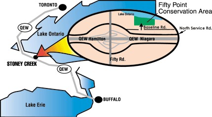
The Fifty Point Conservation Area is at Fifty Mile Point, about 8 1⁄2 miles southeast of the Burlington Canal entrance. Operated by the Hamilton Conservation Authority, Fifty Point is a beautiful 180-acre park that includes a well-sheltered man-made harbour basin and a marina For more information go to the Fifty Point Marina website
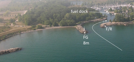
The marina is one of the best on western Lake Ontario, with docking spaces for 330 boats and a double boat launch. Other marina facilities include a fully serviced gas dock and pump-out station, visitor docks, hydro hook-ups, water, showers, washrooms, a laundromat and winter storage facilities.
As Fifty Point marina is within a Hamilton Conservation Area park there is an entrance fee charged to enter the park. As a boater from Fifty Point please advise the front gate of any expected guests and they will be permitted entrance in the park.
Fifty Point is 26 miles southwest of Toronto and 24 miles west of Youngstown and Niagara on the Lake Approaching Fifty Point watch carefully for 8 tall red communications towers (lit by red aircraft obstruction lights at night) about 1 mile east. In Daylight they tend to blend in with the escarpment backdrop. More readily visible from offshore during the day is a single tall communications tower to the west of Fifty Point. There is a large spit of land 700 feet long and 40 feet high, about 200 feet to the east of the Harbour entrance. The harbour is entered between 2 rock breakwaters that form a narrow channel.